In England, lowland peat under agriculture occupies an estimated 243kha, and is responsible for 8.52Mt carbon dioxide equivalents (CO2e) emissions each year (1990-2019 reported figures, 2021); representing 88% of the country’s total emissions from peat. Due in large parts to historic and ongoing drainage, lowland peatlands provide some of the country’s most fertile soils with capacity for high water retention, which can support highly productive arable, horticultural and livestock farming systems. Reducing greenhouse gas (GHG) emissions from cultivated lowland peatlands could generate significant emissions savings, contributing to the Government’s emission target of net zero by 2050.

Emissions abatement from peatlands, particularly lowland peat, is a key focus area of the England Peat Action Plan (EPAP). Restoration is the Government’s central mechanism for delivery, but where restoration is not possible or desirable, the Government has committed to develop more responsible management practices; Defra’s Lowland Agricultural Peat Task Force (LAPTF) has been exploring the changes which might be required to unlock these techniques. Increased ambition on peat rewetting, whether for restoration or more responsible management, is required to meet the Sixth Carbon Budget effort share and net zero targets. We need to improve the evidence base for better water management in lowland peat landscapes as a priority, to design and implement appropriate policies to meet emission reduction targets.

Research widely demonstrates that mean water table depth is the overriding control on peatland emissions. Evidence suggests there may also be the potential to use irrigation as a mitigation technique. To support the Government’s climate ambitions, the Climate Change Committee (CCC) is recommending that 60% of UK lowland peatlands are rewet or sustainably managed by 2050. The CCC define ‘sustainable management’ of lowland peatlands as either a) dynamic water-table management and b) permanent raising of water-tables. To deliver abatement at this scale would require new ways of managing water across lowland peat landscapes.

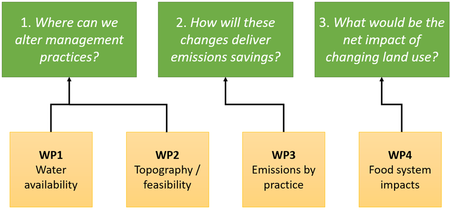
To inform future peatland policy, we must improve our understanding of the true costs of re-wetting drained peatlands, accounting for the practicalities and wider implications of changing how we manage water in lowland peat landscapes. This includes wider co-benefits, e.g., to biodiversity, reducing peat erosion, hydrology. We need to understand what management options are feasible in the lowlands; where they are feasible; what are the risks and opportunities of changing practices; and the wider environmental, social and economic impacts, including on water availability, quality and flood risk. Additionally, we need to explore the net impacts of peat restoration and sustainable management (where water levels allow) on food production in England, and the resulting production shortfall needing to be met elsewhere to ensure stable domestic supply, in alignment with the Government Food Strategy. The Government’s Lowland Agricultural Peat Task Force has discussed the need to better understand the practicalities and economics of system change, highlighting several key evidence gaps to be addressed.

This project aims to develop our understanding of the feasibility and net impacts of changing lowland peat management practices in England. Management practices of interest (although not limited to) include:

  • Raising water table levels (permanently and dynamically);
  • Irrigation methods;
  • Applying mulches;
  • Regenerative agriculture techniques.

Project outputs will be used to improve the Government’s understanding of viable management options for lowland peat; help design policies for peatland management; and consider the net impacts of restoring lowland peatlands. Recognising the need to balance implications for carbon and climate, food and farming, biodiversity, floods and water, we will use the project outputs to inform different solutions which can be rolled-out in combination at a landscape-scale.

We recognise to truly understand the real-world implications of changing management practices on lowland peat, the research and development (R&D) programme will need to include substantial field trials of different management options at larger scales than previous pilots. Field trials will help us to understand the extent to which changes on one farm, or farm cluster, could impact the hydrology, productivity and environment in an area. To deliver meaningful emissions savings, policy needs to understand how much abatement management actions can deliver, how re-wetting will affect what can be farmed, to what extent raising water tables is even possible and the wider environmental and economic impacts of changing management.

Work packages and methods

The R&D programme will cover a 3-year period from January 2024. This programme of work will be made up of 4 key work packages (WPs) to address the three research questions set out in the Objectives (Figure 1).

The work will build on previous Defra-funded project work (Lowland Peat Projects 1 and 2, UKCEH). 

Graphic showing structure of project's 4 work-packages

Work package 1

Assess how much water is required to re-wet the lowlands, whether this water is available, and where it will come from. 

Defra needs to understand if the water resources available in England will meet lowland peat re-wetting requirements and what this will mean for water allocations at catchment and national scales. Hydrological-scale modelling will be required to answer this question, including calculation of the water demand for re-wetting the lowlands, and the impact of meeting these demands on other water systems / requirements (e.g., drinking water, industry, fishing, etc.), the wider environment and the population. As such, water resource and land availability will need to be assessed, i.e., the volume of water available and where it is available at a catchment and regional scale, to understand if a) we have the water budget and storage across seasons to meet demands of re-wetting, and b) if not, what proportion do we have. Additionally, whether existing water retention structures can cope with the increased water levels required for re-wetting, or whether these structures need to be modified.

The standing water volume and volume of water needed to initially raise the water table is of most interest, as well as the importance of seasonal flow-through of water. We need to understand if the required volumes of water are available within existing water infrastructure networks and where the water is stored. The spatial distribution of water storage infrastructure will be important to determine whether the water we have available is in proximity to the lowlands to meet re-wetting demands, and if not, highlight whether significant amounts of water will need to be moved from one catchment to another. We need to understand the capacity to capture and store water in lowland peat landscapes rather than requiring new water inputs where water is not captured presently, and ensure we consider if diversion of water or abstraction from rivers to lowland landscapes would put vulnerable designated sites at risk. We will encourage and facilitate close working with stakeholders in the Environment Agency on this work package where necessary.

The work package will also require predictive models to be developed based off the Met Office’s UKCP18 datasets (and/or similar datasets), considering how projected changes in rainfall, temperature, sea-level, etc. under different warming scenarios may impact on land and water availability to meet demands for rewetting in England, now and into the future. The impact of seasonal variation, and 2°C and 4°C warming scenarios on the water budget will need consideration.

This work package will contribute towards research question 1, alongside Work Package 2.

Work package 2

Assess the impact of landscape topography on the feasibility of raising water tables.

We need to assess how topography will influence the feasibility of raising water tables. Agricultural peat fields are rarely flat and can vary in elevation by a few metres across a single field. Agricultural peatlands are also often lower than the surrounding land and may remain as remnant peat pockets in a landscape that is mostly no longer peat. As such, we need to assess the impact of topography on rewetting across all scales, from landscape, catchment, Internal Drainage Board (IDB) to field scale. This includes consideration of the impact of topography on the risk of saline incursion (e.g., in the Norfolk Broads). The suitability of management options for rewetting land with varying topographies, physical and hydrological properties, and vegetative covers should also be considered.

Catchment fieldwork and earth observation techniques will be required to look at the detailed terrain of sites, their management history and vegetative cover, and the impact of raising the water table in an area. We are currently developing a new baseline England Peat Map (EPM), due to complete in 2024. It may be possible to utilise interim products as part of this work package and outputs could complement the EPM output. LiDAR data may also be used to model where water would flow and where inundation risks would arise if rewetting, to understand the in-field and wider impacts on the surrounding landscape. The different rewetting scenarios (to be agreed with Defra, outlined below) will need to be modelled to understand the implications of topography and water table depth on potential GHG emissions.

Suggested scenarios to model (final scenarios to be agreed with Defra):

  • Raising water tables under lowland peat to 10cm below the surface lowest part of the field
  • Raising water tables under lowland peat to 30cm below the surface lowest part of the field
  • Raising water tables under lowland peat to 60cm below the surface lowest part of the field

Work package 2 will complement the assessment of water availability in Work Package 1 as part of a nested approach to answering research question 1: ‘Where can we alter management practices?’. Together, work packages 1 and 2 will determine water availability spatially and then describe (and rank) where it would be most feasible to raise water tables. A mapped layer of water availability and storage would be useful, to be used in combination with the England Peat Map, currently under development for publication in 2024. The combined work packages 1 and 2 should be brought together to illustrate an index of favourable areas for rewetting vs those less suitable, considering variability in topography and water availability/infrastructure.

Work package 3

Assessment of how peatland emissions vary depending on management models. 

We need to understand how emission factors vary by peat category, management practices and crop type. This includes both grassland and cropland management. This should include large-scale field trials over multiple years using different management options and crop mixes on different peat types in different localities. New field data will be produced to develop system models from. Emissions, both in terms of CO2equivalents (CO2e) and separate measurements for carbon dioxide (CO2), dissolved organic carbon (DOC), methane (CH4) and nitrogen (N2O) will need to be measured. Consideration of the different water demands, practicalities and costs for farmers and the wider environmental risks, opportunities and impacts will be required, including reference to low-cost and high-cost solutions, such as drip-irrigation vs near-surface irrigation. The benefits and viability of integrating management between field trials on a landscape scale and how these may link to hydrological surface and groundwater gradients should be considered.

Questions the field studies could look to answer: 

  • How do emission factors for lowland peat vary between peat category, land management changes, and crop type?  
  • What are the effects of different management treatments on yield?
  • What are the broader effects on the environment at local and landscape scales, including risks and opportunities, e.g., relating to flooding, water quality, erosion, and biodiversity?
  • Which management practices can be used to reduce GHG emissions from grass-dominated lowland peat?
  • What are the implications for the carbon and nitrogen cycles considering rewetting impacts on soil moisture levels?
  • How do emissions differ for lowland peat arable sites in transition to full restoration as opposed to implementing sustainable management practices?
  • How can we model the socio-economic implications of different management models, i.e., impacts on farmers, food security, communities and infrastructure?

Field studies should include at least five management treatments and a control over a minimum of three different sites. Combinations of treatments are of interest as well:

  • Water table manipulation (including dynamic/seasonal management)
  • Surface irrigation
  • Applying a surface mulch
  • Using cover crops
  • Minimum tillage
  • A control (e.g., negative treatment, ‘no change’, or semi-natural and wetland habitat)

Field study requirements:

Field sites will require characterisation of peat depth and carbon content of the profile. Site selection should include a shallow peat, deep peat and wasted peat site. A peat grassland with livestock should be included as one of the sites, and relevant treatments applied.

Crop types should include a conventional cereal crop and a conventional horticultural crop (e.g., leek, celery, broccoli). Having an innovatively farmed horticultural crop (e.g., vertically farmed lettuce) would be a useful comparator to lowland peat management but does not constitute a main management type to be explored.

Measurements from the field studies may include impact of the treatments on: GHG emissions (both total CO2e and separated CO2, CH4 and N2O), water quality and water balance, yield, crop health, soil moisture, average cost of production, wider cost: benefit analysis. Analysis should include life cycle assessment (LCA) of GHG emissions up to the farm gate for each crop on a peaty soil, with comparison to the same/similar crop on a mineral soil, an indoor farming system (where appropriate/available) and importing the crop.

WP3 should also consider the impact of projected changes in climate, i.e., model the relationship between the measured treatment and emissions under 2°C and 4°C warming scenarios. In addition, analysis of the abatement possible when moving from one state to another would be valuable, to develop a modelled matrix of change for expected abatement resulting from land management changes.

The output of the WP will be a set of emission factors, including for intensive grassland; an increased understanding of the wider opportunities, risks and impacts of the management treatments and how they compare to farming similar crops elsewhere; and potential understanding of expected emissions during land management transitions and under a changing climate.

Engagement with stakeholders (e.g., landowners, farmers) will be required and trials may act as useful pilot sites for stakeholder visits, to demonstrate how different management practices may be used to manage lowland agricultural peat more sustainably.

This work package will contribute towards research question 2.

Work package 4

Assessment of the impact on food systems if lowland peat is taken out of production.

We need to understand whether raising water tables on lowland peat leads to genuine emission reductions, or in emissions being redistributed as food production is shifted elsewhere. This includes the resultant socio-economic impacts on farmers, communities, food security and infrastructure, including water table levels and water resources. Analysis should include a “no change” scenario, projecting future food production under no change of practice/land use.

The work package should model the following:

  • How much lowland peat in England is currently under agricultural management, what types of agricultural management systems, and what is the modelled nutritional content / calorie output / yield from this land?
     
  • Does shifting production from England’s peaty to mineral soils lead to genuine emission reductions when considered at the system level, is there the land capacity to do so, and does this lead to other costs / benefits?
     
  • Would taking lowland peat out of production lead to offshoring of emissions by increasing our reliance on imports if production demand cannot be met elsewhere in England, and to what extent?

The work package should assess current production and production systems on lowland peat in England, then consider shifting production primarily off lowland agricultural peat to other mineral soils and vertical/innovative farming alternatives in England. This includes whether the land has the capacity to meet the added demand generated by this shortfall in production on lowland peat, the requirements for more inputs (e.g., fertiliser) and the resultant impact on national emissions. Finally, consider whether taking lowland peat out of production increases our reliance on imported products if demand cannot be met nationally, and to what extent this may lead to offshoring of emissions.

The work package should answer the questions in terms of GHG emissions and food security, but also consider land pressures, including the social and economic impacts of shifting production off lowland peat and onto other landscapes (and land uses), as well as the wider cost: benefits, e.g. impact on biodiversity, water quality, soil quality.

This work package will contribute towards research question 3.

logo circular logo of water, soil, plants and clouds